 by
by We recently wrote an article about the best places to visit in Iceland. We realized that many of our favorites are waterfalls. Therefore, we decided to dedicate a separate article only to our top 10 waterfalls in Iceland. Without further ado, here they are.
Click the waterfall name to skip down to its description:
- Kirkjufellsfoss
- Dynjandi
- Godafoss
- Dettifoss and Selfoss
- Hengifoss
- Svartifoss
- Skogafoss
- Seljalandsfoss and Gljúfrabúi
- Gullfoss
- Öxarárfoss
Iceland’s must-see waterfalls
We present to you our favorite Icelandic waterfalls here in clockwise order around the island, starting in Reykjavik. Numbers on the map correspond to the destinations in this article. For more information about each, create your own trip and download the premium roadbook.
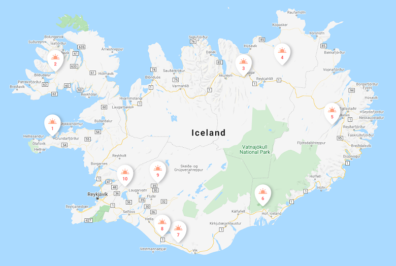
As you can see, these destinations are mostly located along the Ring Road. This is Iceland’s main highway, Route 1, which encircles the Island. You can easily drive a regular passenger car to see these highlights.
![]() DetourOn Tip: To access our list of things to do in Iceland, visit the DetourOn planning page. Type “Reykjavik” in the search box and select from our pre-loaded templates to see our suggestions.
DetourOn Tip: To access our list of things to do in Iceland, visit the DetourOn planning page. Type “Reykjavik” in the search box and select from our pre-loaded templates to see our suggestions.
To build your own itinerary and print out a personalized roadbook, start with these templates and modify them as you see fit.
Hint: You can add more days to the planner and move destinations around.
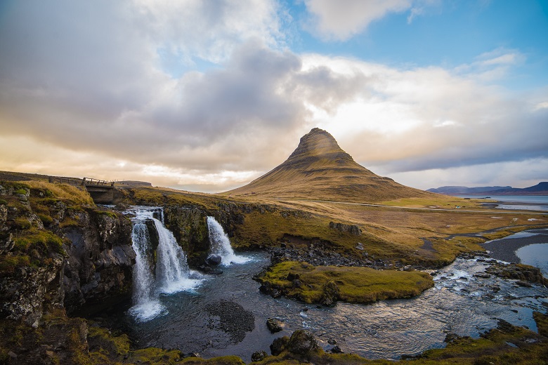
1. Kirkjufellsfoss
Kirkjufell, on the Snæfellsnes peninsula, is one of the best-known and photographed mountains in Iceland. Its name translates to Church Mountain, as some say it resembles a church. It is most iconic when photographed with Kirkjufellsfoss, a small scenic waterfall in the foreground.
Best way to visit Kirkjufellsfoss
From Reykjavik, it takes about 2.5 hours to drive to the Kirkjufell parking lot. It is located on Road 54 which circles the Snæfellsnes Peninsula. The parking lot, right on the road, is large and obvious – and often full. An easy 5-minute walking path departs from the parking lot to the viewing point of the mountain and waterfall. Parking is free.
NOTE: This is an extremely popular stop. Though a quick turnover, waiting for a parking spot could result in slowdowns on the main road.
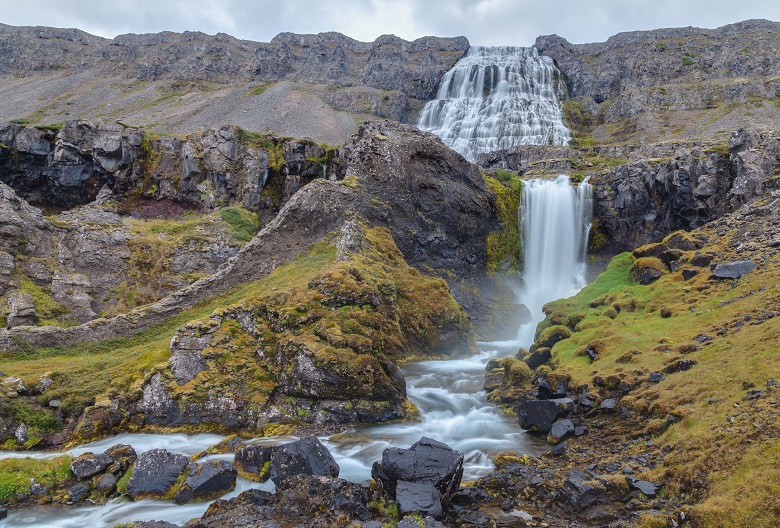
2. Dynjandi Waterfall
Dynjandi, meaning “thunderous,” may be the most impressive waterfall in Iceland. It certainly is the biggest and loudest in the Westfjords. Its upper section is made up of a gradually widening set of cascades. They culminate in a 100 m free fall that makes up the lower section. Chances are you will not be alone here since this is the most visited site in the Westfjords. It is, however, more distant and therefore less visited than other Icelandic destinations.
Best way to visit Dynjandi
From Reykjavik, it takes about 5 hours to drive to the Dynjandi parking lot. It is located just off Road 60 which follows the southern coastline of the Westfjords.
To get here from the Snæfellsnes peninsula, we recommend taking the 3-hour ferry from Stykkisholmer to Brjánslækur. From there, follow Road 62 north to Flókalundur. Turn left onto Road 60 and proceed for about 30km. When the road descends toward the fjord, take a left to the waterfall. The turnoff is large and obvious. Parking is free.
A 15-minute uphill walking path leads along the powerful waterfall from bottom to top, offering panoramic views of the fjord below. Prepare to climb lots of steps.
NOTE: Road 60 is a well-maintained gravel road. Check road conditions before departing. Waterproof and protect your electronics as the spray from the waterfall could be strong.
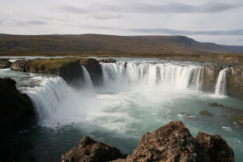
3. Godafoss
On the way from Akureyri to Lake Myvatn, don’t miss the Waterfall of the Gods, Godafoss. It’s only 12 m tall, but shaped in a 30 m semicircular curve. This is easily one of Iceland’s most spectacular waterfalls! It’s also extremely popular, so prepare yourself for crowds.
Here, in the year 1000, the Lawspeaker Þorgeir Ljósvetningagoði announced Christianity the official religion of Iceland. He symbolically threw his statues of the Norse gods into the waterfall.
Best way to visit Godafoss
From Akureyri, travel 30 km east on Road 1. Turn right to the big paid parking lot west of the waterfall. From here, a wide easy path follows the river to the base of the falls. It is also possible to walk along the east rim of the river from the restaurant/service station at Fosshóll.
NOTE: Due to its proximity to Akureyri and the Ring Road, this is a very popular area!
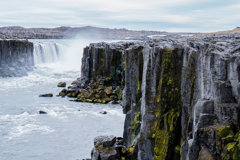
4. Dettifoss and Selfoss
Another one of Iceland’s must-see waterfalls is Dettifoss, the most powerful waterfall in Europe. Just 500 m from it is the beautiful Selfoss. Though less powerful, it is no less impressive, appearing as a series of calmer waterfalls.
Located in Jökulsárgljúfur Canyon, a detached portion of Vatnajökull National Park, Dettifoss drops a mere 44 m over a 100 m long stretch of sheer canyon cliffs. It is so powerful you’ll hear it before you reach it, and you’ll feel the ground shake when you’re there.
Best way to visit Dettifoss and Selfoss
In summer, access Dettifoss from the gravel road on the east side of the canyon. Because it is a gravel road, it is much less visited than the west access point.
To get here from Reykjahlíð, drive 36 km east on Ring Road 1. Turn left just after the bridge over the River Jökulsá onto gravel Road 864. Continue 31 km and turn left (marked Dettifoss) to the big parking lot.
To get here from Asbyrgi, drive 2.5 km east on Rd 85, then turn onto gravel Rd 864 and continue 25 km south. Turn right (marked Dettifoss) to the big parking lot.
In winter, the only access is from the west. From Reykjahlíð, drive 25 km east on Ring Road 1. Turn left onto Road 862. Proceed 20 km north on this paved road, then turn right toward the big and popular parking lot.
From either side, walk about 1 km from the parking lot to the first view of Dettifoss. Continue another 500 m along the canyon rim southward for views of neighboring Selfoss. Parking is free.
NOTE: Road 864 between Dettifoss and Asbyrgi is a gravel road, only open in summer. The hike on either side is on uneven terrain. It may be slippery when wet. Waterproof and protect your electronics as the spray from the waterfall is strong.
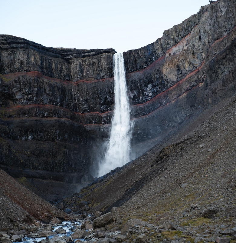
5. Hengifoss
The 128 m tall Hengifoss, the Hanging Waterfall, is the third tallest waterfall in Iceland. Though this narrow ribbon of water is pretty, the waterfall’s main attraction is the striking rock behind it. Horizontal layers of red clay – a result of iron oxides – divide the black basalt cliff face. The red is so vibrant it looks as if the rock is bleeding.
Best way to visit Hengifoss
On Road 1 just north of Egilsstaðir, cross the bridge over Lake Lagarfljot. Turn left onto Road 931 and follow the northwestern shore of the lake for 35 km. Continue straight onto Rd 933 (Rd 931 turns left back over Lake Lagarfljot). Park at the large parking area on the right. Parking is free.
You need to make a bit of a physical effort to get here. A 5 km, 2 hour roundtrip hike leads to the base of the waterfall. Though not very difficult, the uneven walking path constantly climbs uphill. This combination gives the trail a moderate rating, with 300 m elevation gain. Benches along the way allow you to rest and enjoy the view.
After the hike, for a scenic loop, return to Egilsstaðir via Rd 931 following the southeastern shore of the lake.
NOTE: At low flow, usually in August, It is possible to walk behind the waterfall, where there is a small cave. Waterproof and protect your electronics if you approach the water. At high flow, it may not be able to reach the base of the waterfall at all.
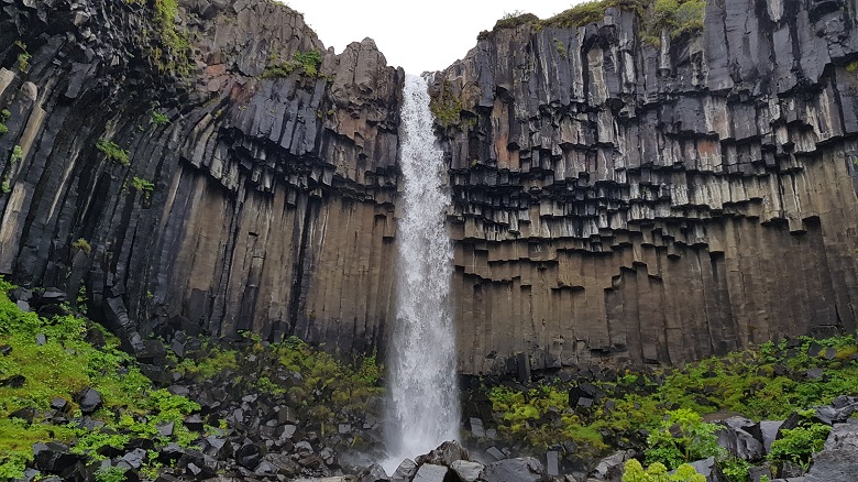
6. Svartifoss
Svartifoss, the Black Waterfall, is so named thanks to the black hexagonal basalt columns behind it. In fact, those very walls serve as an inspiration to many Icelandic architects. Notice the resemblance to Hallgrímskirkja in Reykjavik, for instance.
NOTE: Svartifoss is the main draw to the Skaftafell region of Vatnajökull National Park. Though it requires some hiking to get to it, you’ll meet more people than you would expect on the trail.
Best way to visit Svartifoss
The hiking trail to Svartifoss begins at the Skaftafell Visitor Center. It is located 2 km north of the Ring Road, 20 km northeast of Hof. You must pay to park here. If you have time, we recommend first hiking directly to Svartifoss. The 1.5 km uphill walk will take about 30-45 minutes one-way. From there, break away from the crowds and continue your hike to Sjónarnípa. In total, it is an 8 km moderate loop that passes through tundra and over a few mountain streams. You may even spot some reindeer up here!
At Sjónarnípa, you’ll be rewarded with an impressive viewpoint over the Skaftafellsjökull glacier terminus. Best of all, you’ll probably have this trail to yourself!
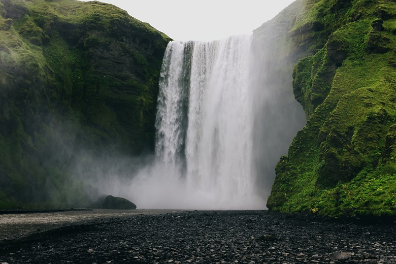
7. Skogafoss
Skogafoss is one of Iceland’s most famous waterfalls, located just off the Ring Road. It is 60m tall and 25m wide, often graced by a lovely rainbow. It gains much popularity from scenes in such movies as Thor: The Dark World and The Secret Life of Walter Mitty.
Fun fact: The cliff from which these falls descend is the former Icelandic coastline, which has now receded in a seaward direction about 5 km.
Best way to visit Skogafoss
From Reykjavik, it takes about 2 hours to drive directly to the waterfall. Take Rd 1 for 90 km, then turn left toward the waterfall and the village Skogar. The waterfall is visible from the Ring Road. Parking are free. A steep staircase from the parking lot (370 steps) leads to a viewing platform above the waterfall.
If you have time to spare, climb the ladder over the fence and follow the path upstream along the river. This is the beginning of the Fimmvörðuháls Trail, one of the most famous backpacking trails of Iceland. You only need to follow it a short distance to appreciate the beauty and serenity of this landscape!
NOTE: It is possible to walk right up to the base of the waterfall. However, the spray is quite powerful and will get you drenched long before you arrive.
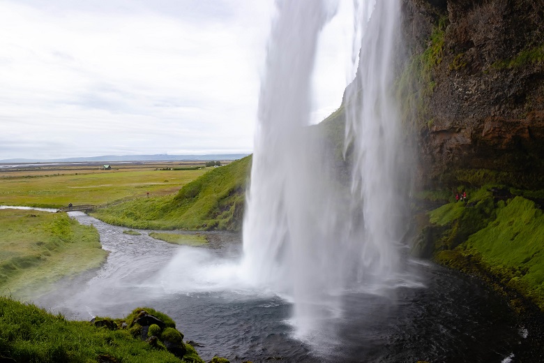
8. Seljalandsfoss and Gljúfrabúi
The 60 m tall Seljalandsfoss is another one of the most popular waterfalls in Iceland. Once again, we mention it here because we think it’s worth battling the crowds. The waterfall is easily accessible off the Ring Road. A short walking path from the parking lot leads to a small cave behind the waterfall.
From the same parking lot, walk to the 40 m tall Gljúfrabúi waterfall, one of Iceland’s hidden gems. Literally, you won’t see it until you get inside the gorge that it creates. This also explains its name, which translates to “the inhabitant of the gorge”. In reality, the top of the waterfall is visible from the trail, but the real spectacle is inside the gorge.
Best way to visit Seljalandsfoss and Gljúfrabúi
About two hours on the Ring Road east from Reykjavik, turn north on Road 249. A big sign marks the turn and leads to the paid parking lot for Seljalandsfoss. Plan to spend about 15 minutes walking to the base of the waterfall, behind it, and back to the parking lot.
From the same parking, a wide walking path leads northward to Gljúfrabúi. A roundtrip from here will take about 30 minutes.
There are some free parking spaces a bit past the main parking lot, directly in front of Gljúfrabúi. A roundtrip from here to Gljúfrabúi will take 10 minutes.Spots are limited.
NOTE: Prepare to get drenched if you go inside the Gljúfrabúi gorge or behind Seljalandsfoss. Bring rain gear and protect your electronics.
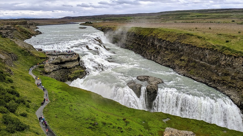
9. Gullfoss
Everybody does it, and you must too! You just cannot go to Iceland without visiting Gullfoss, the Golden Waterfall. In short, this is a bright blue two-step waterfall that seems to simply disappear into the earth. Green vegetation surrounds the waterfall in summer, and rainbows often appear above it. In winter, many photographers come here in the middle of the night to photograph the amazing northern lights above the grand waterfall.
Best way to visit Gullfoss
It takes two hours to drive to Gullfoss from Reykjavik. On the way you’ll pass Thingvellir National Park, which is certainly worth a stop. Parking at Gullfoss is free.
NOTE: This is one of the most visited sites in Iceland. Expect crowds.
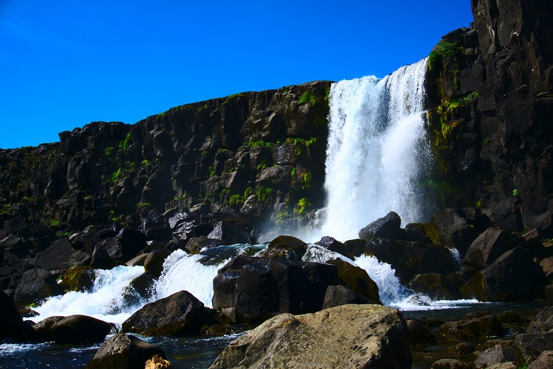
10. Öxarárfoss – Thingvellir National Park
In all honestly, Þingvellir National Park and the Öxarárfoss waterfall may not be the most scenic locations in Iceland. However, whatever they lack in natural beauty they more than makes up for in history and geography.
Þingvellir National Park (pronounced Thing-vet-lir) is recognized as a UNESCO world heritage site. This is the site of Iceland’s first parliament, one of the earliest parliaments in the world. It is also one of the only places on Earth to simultaneously stand on the Eurasian and North-American tectonic plates.
Öxarárfoss waterfall drops over the cliffs of Almannagjá gorge, which marks the eastern boundary of the North American tectonic plate. An easy well-maintained and well-traveled walking path leads through this gorge. It is actually a rift valley created by the separation of the Eurasian and North American tectonic plates. In fact, at times, you’ll be able to touch both continents simultaneously!
Fun fact: Öxarárfoss is actually a man-made waterfall. As strange as this may sound, geologists and historians have discovered that the river Öxará was moved sometime in the 9th century. To learn more about this, add the Öxarárfoss hike to your DetourOn trip plan and download the roadbook for it.
Best way to visit Öxarárfoss
From Reykjavik, it takes about 45 minutes to drive to the park. Take Rd 36 for 30km, then turn right to the visitor center. Entrance to the national park is free, but you must pay a daily fee for parking. From here there is a nice easy path through the Almannagjá rift that leads to Öxaráfoss. It is about a 15-minute one-way walk.
Another way of hiking to the waterfall is from Langistigur trailhead. It is located just off Rd 36, 2.4 km north of the Visitor Center. This 15-minute hike is a bit more rugged, and therefore less popular. Needless to say, we like this way much better because it is less visited.
NOTE: Again, we have to warn you that this is a very popular area!
On a side note, our favorite way to view the meeting of the continental plates is by snorkeling/scuba diving at Silfra. Just be warned: The water is frigid! In order to protect the area, you must hire a guide to snorkel or dive here.
Conclusion
For more information about any of these destinations, add them to the DetourOn Planner and print out the Premium Roadbook. You’ll have everything you need: Directions to your chosen locations, short history and fun facts about each, and practical information to know before you go. Check out our template of Iceland to get started.
Get in touch with us if anything is missing or if you have any questions. Or just to say hi.